
 |
| HRP - Day 8 |
Breakfast at 6am, then a rough rocky scramble up and over the Col d'Arremoulit to enter Spain for the first of four border crossings today. It was quite wild and bouldery beside the Lacs d'Arrie, so I was glad I hadn't continued last night. An icy river crossing gave me the first use of my ice axe to maintain balance. The views as you turn the corner towards the Embalse de Respumoso and surrounding hills are quite stunning, and difficult to stop photographing.
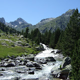
Once I reached the lake I was briefly back on the GR11 along past the Refugio, but then parted company again to aim towards the Col de la Fache 2664m, which had a few old snow patches but nothing too steep. Once over the col I was back into France on the descent to Refuge Wallon which I'd visited with Ellie in 2008. It's a beautiful place to relax with its sparkling rapids and cascades.
After a short break, lazing beside the river and re-taping my toes, I set off on the next big climb to Col d'Arratille 2528m which crosses back into Spain and overlooks the head of the Valle de Ara which leads down to Torla. It was getting fairly late, so you never see any other hikers on the hill at this time in the evening.
Once over the col, the track winds around a steep slope on a contour to reach the Col des Mulets which crosses back into France with a very steep descent down to the Oulettes du Vignemale, where I've always wanted to pitch my tent beneath the dramatic north face of the Vignemale.
View HRP - Day 8 in a larger map
No comments:
Post a Comment